- Home
- Departments
- Planning & Economic Development
- POCD (2019)
- 5 Maintain Community Assets
5 Maintain Community Assets
City residents know that the city has some incredible neighborhoods and community amenities. Maintaining and enhancing these assets will help to sustain the overall quality of life within the city. This includes.
- Maintain And Enhance Residential Areas
- Preserve Open Space
- Manage Activities in Coastal Areas
- Enhance Community Character
- Protect Natural Resources
- Maintain An Efficient Transportation System
- Manage Utility Services
About one-third of the land area in the city is devoted to residential use. Within its borders, the city has a variety of housing types ranging from single-family and two-family dwellings to larger multi-family complexes.
Within these residential areas, the city intends to:
- Maintain and improve the integrity of residential neighborhoods in order to preserve and enhance the overall quality of life for residents,
- Continue to discourage the establishment of social service uses (such as halfway houses and community residential counseling facilities), and
- Promote a variety of housing types to help address the housing needs of the community and the region. (see Section 4.2 of the POCD on page 30)
The following neighborhood compatibility policies are established for single-family neighborhoods:
- Continue efforts to maintain the integrity and visual qualities of single-family neighborhoods,
- Encourage maintenance and continued renovation / improvement of single-family housing.
- Pursue funding which will provide for housing rehabilitation and continue to implement rehabilitation programs/projects that retain the viability of single-family neighborhoods,
- Discourage the intrusion of commercial, industrial, or parking uses into single-family neighborhoods,
- Strive to ensure appropriate transitions between commercial, industrial, and parking uses to residential neighborhoods, and
- When possible, encourage or require elimination of commercial parking lots in single-family residential areas.
The following neighborhood compatibility policies are established for multi-family neighborhoods:
- Encourage continued renovation / adaptation of multi-family housing to meet current and future housing needs,
- In the event of a request to rezone property to multi-family use, such rezoning should address an identified housing need in the City and be located in an appropriate location (such as a transitional use from major roads or business uses to a single-family neighborhood).
Strategies To Maintain & Enhance Residential Areas
| Priority | Leader | Partners | |
| Overall | |||
| 1. Continue to maintain and improve the integrity of residential neighborhoods in order to preserve and enhance the overall quality of life for residents. | 8.33 | PZC | Staff |
| 2. Continue to discourage the establishment of new social service uses (such as halfway houses and community residential counseling facilities) in residential areas. | 5.56 | PZC | Council Staff |
| Single-Family Neighborhoods | |||
| 3. Continue efforts to maintain the integrity and visual qualities of single-family neighborhoods and discourage the intrusion of commercial, industrial, or commercial parking uses. | 6.67 | PZC | Staff |
| 4. Continue to pursue funding which will provide for housing rehabilitation. | 5 | Staff | |
| 5. Continue to implement rehabilitation programs/projects that retain the viability of single-family neighborhoods. | 6.11 | Staff | |
| 6. Strive to ensure appropriate transitions between commercial, industrial, and parking uses to residential neighborhoods, and | 3.89 | PZC | Staff |
| 7. When possible, encourage or require elimination of commercial parking lots in single-family residential areas. | 6.67 | PZC | Staff |
| Multi-Family Neighborhoods | |||
| 8. Encourage continued renovation / adaptation of multi-family housing to meet current and future housing needs, | 7.78 | PZC | Staff |
| Click here for the Responsibility Legend | |||
The preservation of open space is a significant element of the Plan because of the City's desire to preserve important resources, enhance community character, and augment the quality of life in the city.
For the Plan, "open space" is defined as land permanently preserved from development and committed in perpetuity for conservation, passive recreation (such as trails), or preservation of community character. Note that active recreation fields and areas are addressed in the Section 6.2 of the POCD (page 64).
The Open Space Plan identifies the following areas:
- Existing Open Space includes state, municipal, and private lands that are currently preserved as open space (dedicated open space) or used for open space-type purposes (managed open space) or are community facility uses that are complementary to open spaces.
- Desirable Open Space includes areas along Birch Plain Creek and other areas that are desirable to preserve as open space due to their overall scenic and/or resource value to the community and/or their proximity to existing open space areas in the city or the Town.
Click the map below to enlarge and map will open in new window.
Birch Plain Creek
For several decades, the Town of Groton and the City of Groton have been seeking to establish a "greenbreak" along Birch Plain Creek.
From both perspectives, the Birch Plain Creek corridor provides an important opportunity to interconnect pathways in both communities and regionally.
Funds have been programmed into the 2019-2024 Capital Improvements Program to extend the Birch Plain Creek Greenway.
With regard to open space, the City of Groton intends to:
- increase the amount of permanently dedicated open space in order to protect the environment and enhance the character and quality of life in the City.
- interconnect open space areas so that it will become possible to travel among them by a pathway system.
- establish multi-use paths and sidewalks that link different areas of the City together.
- Seek opportunities to create a boardwalk along the Thames River.
The preferred method of preserving open space in the City is through ownership by a public entity (such as the City of Groton, the Town of Groton, or the State of Connecticut) or a conservation organization (such as the Avalonia Land Conservancy or The Nature Conservancy). This method will also ensure that public access is provided, when and where appropriate. Conservation easements and ownership by homeowner associations are not encouraged for preserving open space (since they typically do not allow for public access) but can be used for protection of sensitive natural resources or scenic views.
To help preserve open space, the City should seek to enhance the existing Open Space Fund in order to provide the resources to acquire important open space parcels when they become available.
Since open space can be difficult to come by in a community which is about 97% developed/committed, the city should strive to ensure that any open space which is acquired be preserved as open space in perpetuity.
Strategies To Preserve Open Space
| Priority | Leader | Partners | |
| 1. Seek to increase the amount of permanently dedicated open space in order to protect the environment and enhance the character and quality of life in the city. | 5 | PZC | BPC Staff |
| 2. Seek to interconnect open space areas so that it will become possible to travel among them by a pathway system | 5 | CWC | PZC BPC Staff |
| 3. Seek to establish multi-use paths and sidewalks that link different areas of the City together. | 5.56 | PZC | BPC PW Staff |
| 4. Seek opportunities to create a boardwalk along the Thames River, north of Electric Boat. | 6.11 | PZC | Council Staff |
| 5. Continue to work with the Town of Groton to create an open space corridor along Birch Plain Creek. | 3.33 | PZC | Staff TOG BPC CWC |
| 6. Strive to ensure that any open space which is acquired be preserved as open space in perpetuity. | 2.78 | PZC | Staff |
| 7. Seek to enhance the existing Open Space Fund in order to provide the resources to acquire important open space parcels when they become available. | 2.78 | Council | PZC CWC |
| Click here for the Responsibility Legend | |||
Groton has always had a strong relationship with the sea and coastal areas are where the land and sea interface. Finding the right balance between "conservation" and "development" in coastal area is important. Issues to be considered include:
- Protecting coastal resources,
- Providing for coastal access, and
- Managing water-dependent uses.
Issues related to sea level rise and coastal flooding are addressed in Section 6.1 of the POCD (page 61).
Protect Coastal Resources
The following map shows what is considered to be the "coastal area" in the city. Section 22a-93 of the Connecticut General Statutes defines coastal resources as:
- Coastal bluffs and escarpments
- Rocky shorefronts
- Beaches and dunes
- Intertidal flats
- Tidal wetlands
- Freshwater wetlands and watercourses
- Estuarine embayments
- Coastal hazard areas
- Developed shorefront.
- Islands
- Nearshore waters
- Offshore waters
- Shorelands
- Shellfish concentration areas
Coastal resources also include the plants and animals that inhabit the shoreline area.
The city intends to protect these coastal resources as they exist today and as they evolve in the future (such as salt marsh advancement) in response to sea level rise and climate change.
Click the map below to enlarge & map will open in new window.
Coastal Access
One way the City has been enhancing coastal access is illustrated by the acquisition of the Costa property on Thames Street (see map on page 13).
The City intends on improving this property as a passive waterfront park and possibly, in the future, with a dock and pier for boating and/or fishing.
Efforts such as these will continue in the future as opportunities become available.
Provide For Coastal Access
Coastal access of all kinds (visual access, public access, boating access, etc.) is important to coastal communities like the City of Groton. The City is fortunate to offer a variety of public access attractions ranging from the urban waterfront along Thames Street, with sweeping views of the lower Thames River, to swimming at Eastern Point Beach, to harbor and wetland viewing at Bakers Cove and Birch Plain Creek. An up-to-date listing of coastal access points in the city (and elsewhere in the state) is available online.
Preserving, maintaining and enhancing coastal access is a key element of the coastal management program. In Groton, this includes:
- Scenic Views - Due to the importance of coastal views to community character, the city will consider ways to protect, preserve and enhance visual access to (and from) Long Island Sound, the Thames River, and coastal resources in general.
- Public Access for People - The City will seek to improve physical access for people to the waters of Long Island Sound, the Thames River, and coastal resources in general. This may include:
- Requiring public access (such as boardwalks or walkways along the water and/or pathways to the water) as part of development proposals, and
- Acquiring waterfront property, if it becomes available, in order to provide a waterfront park or other community amenity.
- Public Access for Boating - Groton will continue to encourage water access and associated facilities for recreational boating such as the State Boat Launch under the Gold Star Memorial Bridge.
The city intends to seek public access to the coastal areas whenever possible and appropriate.
Manage Water-Dependent Uses
Water-dependent uses are uses which require access to the water as a functional component of the use. Groton has a tradition of maritime operations that continues to the present day, and this includes uses such as:
- Electric Boat Corporation (ship building)
- Buckeye Oil Terminal (delivery by ship)
- Shennecossett Yacht Club, Pine Island Marina, and other dock and/or marina facilities, and
- Commercial excursion boats (commercial and/or recreational fishing).
It is a goal of the State of Connecticut to preserve waterfront locations for such water-dependent uses. A use which is not strictly water-dependent (such as a restaurant or a residential development), can be rendered water-dependent by providing for physical access to the water for the general public.
In recognition of its industrial waterfront, the city wants to promote balanced development of the coastal area to ensure full utilization of that area while increasing and enhancing water access, recreational opportunities, and water-dependent uses. Maritime operations should be protected, and improvements and expansions should be encouraged provided that any negative impacts on local residents and businesses (such as land-side impacts of waterside uses) are minimized.
The City's Harbor Management Plan (and Harbor Management Commission) help manage issues related to water-dependent uses.
Strategies To Manage Coastal Areas
| Priority | Leader | Partners | |
| Protect Coastal Resources | |||
| 1. Continue to protect coastal resources. | 10 | PZC | DEEP CWC Staff |
| Provide For Coastal Access | |||
| 2. Seek ways to protect, preserve, and enhance visual access to and from coastal areas and resources. | 6.11 | PZC | Staff |
| 3. Continue efforts to enhance physical access for the general public to and from coastal areas and resources including: a. linear pathways along the waterfront, and/or b. lateral connections to the waterfront with linear pathway along the street (e.g. – the Thames Street area) where a linear pathway is not feasible or practical. | 7.78 | PZC | CWC DEEP Council Staff |
| 4. Consider purchasing strategically located waterfront parcels when they become available in order to provide for coastal access. | 2.22 | Council | DEEP |
| 5. Continue to promote boating access to and from coastal waters. | 3.33 | BPC | DEEP Staff |
| 6. Continue to maintain / improve public boat ramps and launch areas for kayaks. | 2.78 | BPC | Staff |
| Manage Water-Dependent Uses | |||
| 7. Continue to manage water-dependent industries / uses. | 5.56 | PZC | Staff |
| 8. Manage recreational marina facilities. | 1.11 | PZC | Staff |
| 9. Support improvements by maritime operations provided that negative impacts to local residents and businesses are minimized. | 1.67 | PZC | Staff |
| 10. Maintain the 2006 Harbor Management Plan and update as necessary. | 5.56 | HMC | Staff |
| Click here for the Responsibility Legend | |||
In the survey conducted as part of the process of preparing the POCD, respondents identified community character as being important to them. This included the many things about the city that made it feel special to them and it also included some things that respondents felt the city needed to do a better job on.
Protect Scenic Resources & Scenic Character
The city is fortunate to contain many significant scenic resources which contribute to community character. The city intends to preserve and protect scenic resources such as:
- Scenic natural areas (such as coastal areas),
- Scenic built areas (such as Thames Street),
- Locations providing scenic vistas (such as from Fort Griswold), and
- Scenic roads (such as Shore Avenue).
Click the map below to enlarge & map will open in new window. 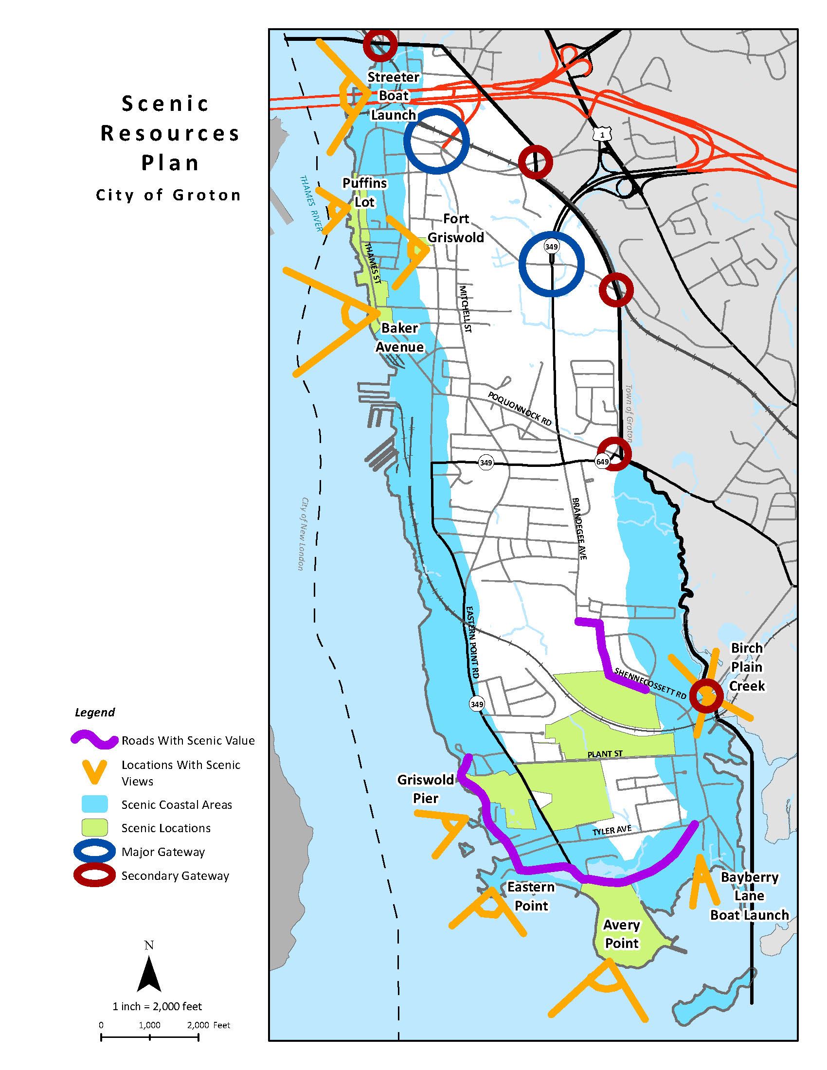
Protect Historic Resources
Historic resources contribute to the overall character and quality of life in the city. The city intends to continue efforts to protect historic resources.
Regulatory Programs - Within the Eastern Point Local Historic District, construction or demolition of buildings or structures or the alteration of external architectural features requires a "certificate of appropriateness." from the City's Historic District Commission. This can provide significant protection to historic resources and character within the district.
Additional protection can come from adopting a demolition delay ordinance which allows time for exploring alternatives to demolition of historic buildings.
Recognition Programs - While recognition programs are largely ceremonial and basically only affect state-funded and federally-funded projects, they help increase awareness of historic resources. Resources listed on the National Register of Historic Places are recognized for their significance in American history. Listings on the State Register of Historic Places are recognized for their significance in Connecticut history. Entries on the National Register are also on the State Register.
In the future, it may make sense to:
- Expand the Eastern Point National Register Historic District to include the Shennecossett Golf Course and related areas,
- Establish a National Register Historic District at the UConn - Avery Point Campus,
- Establish a National Register Historic District (and/or seek National Historic Landmark status) at Fort Griswold, and
- Establish a National Register Historic District (and/or seek National Historic Landmark status) at the Electric Boat Shipyard.
Education Programs - Protection of historic resources can also be promoted through education of property owners and other Groton residents about the importance of these resources to community character and overall quality of life.
Groton Bank
The Groton Bank area was studied for the establishment of a local historic district, but this proposal did not receive the 2/3rds majority vote to establish as required by the Connecticut General Statutes.
The establishment of a local historic district in all or a part of the Groton Bank area could be revisited in the future and put to a vote of the affected property owners.
Enhance Overall Character
Other strategies to maintain and enhance community character include:
- Maintaining design review in the Thames Street and Five Corners areas which have been designated as "village districts,"
- Extending design review principles to development in other areas of the City (except for single-family residential uses),
- Seeking opportunities to enhance streetscapes by litter reduction, pavement narrowing and/or traffic calming (where appropriate), and promoting planting of street trees,
- Placing wired utilities underground in key areas when opportunities present themselves
- Reducing the expanse of parking lots in highly visible areas
- Encouraging (or requiring) the maintenance of residential and other properties,
- Minimizing "nuisances" such as unreasonable noise, illumination, etc.
| Priority | Leader | Partners | |
| Protect Scenic Resources | |||
| 1. Continue to encourage the preservation and protection of scenic resources. | 8.33 | PZC | Staff |
| Protect Historic Resources | |||
| 2. Continue to encourage preservation of historic resources in the City. | 5 | EPHD | Staff |
| 3. Encourage efforts by local organizations to seek recognition for historic resources. | 5 | Staff | |
| Enhance Overall Character | |||
| 4. Encourage development that contributes to “sense of place” in the City. | 7.22 | PZC | Staff |
| 5. Establish design guidelines for commercial development within the community (such as Thames Street and Five Corners) and for multi-family and institutional development. | 1.67 | PZC | Staff |
| 6. Consider expanding street tree planting programs. | 4.44 | CWC | Staff |
| 7. Discourage tall-growing street trees under overhead wires and discourage flowering / fruit trees if not appropriate in certain locations). | 2.78 | CWC | PW Staff |
| 8. Encourage maintenance of street-side areas. | 3.336 | Council | PW |
| 9. When opportunities arise, pursue placing wired utilities underground in key areas in order to enhance scenic character. | 6.11 | UC | Council PZC Staff |
| Click here for the Responsibility Legend | |||
Click the map below to enlarge and map will open in new window. 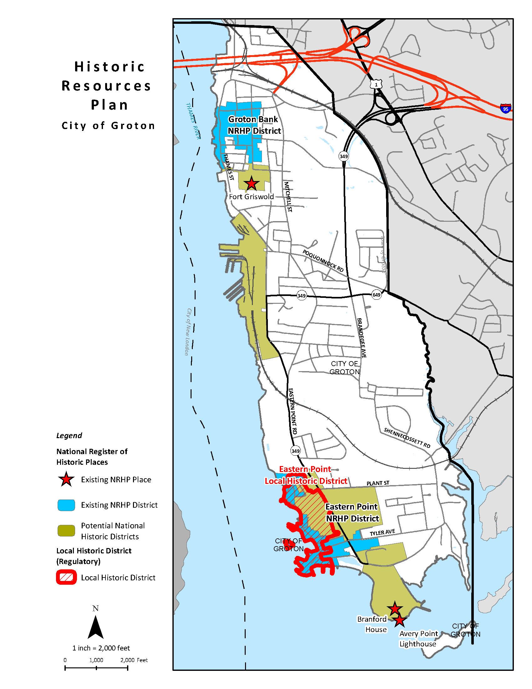
Natural resources perform a variety of important environmental functions and contribute to environmental health and overall community character in the city. The city intends to continue to protect natural resources in the city for current and future generations.
Protect Water Quality
Protection of water quality is, and will continue to be, the most important natural resource priority in the city.
The New London-Groton area has been identified as a priority area for water quality management and the fact that shellfish beds in and around the city are occasionally closed due to pollution from runoff is an indication that more can and should be done to protect water quality.
The city is addressing state and federal stormwater requirements (known as the "MS4 Permit") and this will help reduce pollution from a variety of sources.
In addition, the City adopted zoning regulations related to implementing "low impact development" (LID) approaches to stormwater runoff as part of any new development in the City. While retrofitting of existing drainage systems will take time, this will also pay dividends in terms of water quality. In the meantime, regular street sweeping and drainage maintenance (including trapping, removing, and suitably disposing of sediment from storm drains) will help.
The LID approaches to stormwater runoff also help address issues related to the quantity of runoff. While several areas of the City have bedrock close to the surface and may not be able to do much in terms of stormwater capture and infiltration, other areas will be able to reduce flooding and promote infiltration to support a more natural water cycle in terms of groundwater flows.
Water Quality
Protection and improvement of water quality in the city and adjacent waters can involve a variety of activities:
- Reduction of fertilizer / pesticide use
- Marine boat pump-outs
- Stamping of catch basins that discharge to coastal waters.
The city encourages participation in the "Clean Marinas" program which is a voluntary program that encourages marina operators to minimize pollution.
As a companion to the Clean Marina Program, the Clean Boater Program encourages the state's boaters to learn about and use clean boating techniques when operating and maintaining their boats.
Click the map below to enlarge & map will open in new window.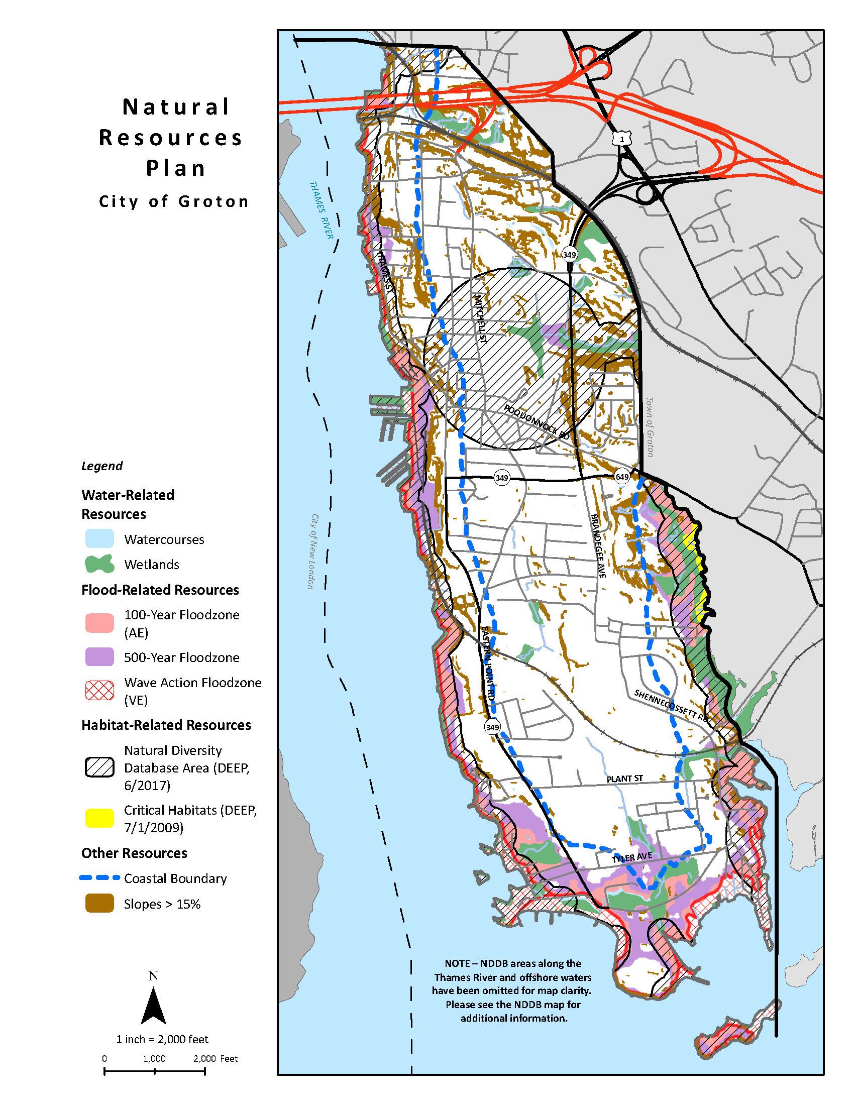
Protect Key Natural Resources
In addition to protecting water quality, the city intends to protect the following natural resources as well:
- Watercourses (drainage, water quality, etc.),
- Wetlands (water quality, habitat, flood control, etc.), and
- Steep slopes (erosion potential, etc.).
The city intends to continue requiring setbacks and buffers to separate development activities from water resources. While large setbacks will not always be possible, even small setbacks would be of benefit in areas with little or no protection currently.
Manage Floodplain Activities
The city also intends to effectively manage floodplain activities and minimize new development in these areas. This is especially relevant in coastal "V" flood zones (areas in which structures are subject to potential wave damage during coastal storms). With increasing concern over sea level rise and coastal storms, discouraging development in such areas and promoting a gradual retreat from vulnerable low-lying waterfront is good public policy.
Protect Natural Diversity Resources
The city also intends to protect "natural diversity" resources (such as endangered species, unique habitats, and/or scenic resources). The zoning regulations require any site identified on the Natural Diversity Database or map maintained by the Connecticut Department of Environmental Protection (DEEP) to obtain a report indicating that the resource on the site will be protected as part of any development proposal.
The city also intends to prevent the introduction of non-native species and diminish the presence of invasive species in the city, especially as part of new development applications.
Strategies To Protect Natural Resources
| Priority | Leader | Partners | |
| Protect Water Quality | |||
| 1. Continue programs and efforts to protect and improve water quality in the city. | 8.33 | CWC | PZC DEEP EPHD HMC Staff |
| 2. Continue to require the use of “best management practices” to treat stormwater in new development. | 2.78 | PZC | DEEP Staff |
| Protect Key Natural Resources | |||
| 3. Continue to protect watercourses and wetlands. | 5.56 | CWC | PZC Staff |
| 4. Continue to protect steep slopes (>15%). | 2.22 | PZC | Staff |
| Manage Floodplain Activities | |||
| 5. Continue to manage floodplain activities. | 5 | PZC | Staff |
| 6. Minimize new development in floodplain areas. | 6.11 | PZC | Staff |
| Protect Natural Diversity Resources | |||
| 7. Continue to protect natural diversity resources, including those identified on the Natural Diversity Database or map. | 2.78 | PZC | DEEP Staff |
| 8. Seek to prevent the introduction of non-native species and diminish the presence of invasive species. | 2.22 | PZC | CWC Staff |
| Click here for the Responsibility Legend | |||
The city is fortunate to be well served by a roadway network for vehicular circulation and by a bus transit system. The city intends to support, maintain and enhance this transportation system for the benefit of residents, businesses, employees, customers, and visitors.
Roadway System
The overall road system in the City is essentially established and is well configured to meet the community's needs. However, the City intends to maintain an efficient (and cost effective) transportation system by:
- Continuing to maintain pavement condition as cost effectively as possible (pavement management),
- Managing activities along existing roadways in order to preserve the roadway capacity (access management), and
- Implementing approaches on selected roadways, as necessary, to reduce cut-through traffic on residential streets, truck traffic on local streets, and speeding on some thoroughfares (traffic calming).
Road Classifications
| Limited Access Highways - Roads that serve regional traffic and have limited access. |
|
| Arterials - Highways which carry both regional and local traffic from the collectors. |
|
| Collectors - Take traffic from local streets and direct it to arterial highways system. |
|
| Local - Roads providing access to neighborhoods and individual properties. |
|
Click the map below to enlarge & map will open in new window.
Bus Service
Several types of transit services are available in the city and the City intends to support the availability of such services to meet the needs of residents, employers, employees, and visitors.
Public transit service available in the City includes buses operated by the Southeast Area Transit (SEAT) system. SEAT offers several fixed bus routes that serve a number of employers and neighborhoods in the City.
In addition, there is a "dial-a-ride" service for the elderly and disabled operated by the Town of Groton.
The city intends to continue encouraging major employers to promote carpooling, vanpooling, employer shuttles, and other techniques to alleviate traffic congestion at peak hours, reduce the size of parking lots, and reduce air pollution.
Click the map below to enlarge & map will open in new window. 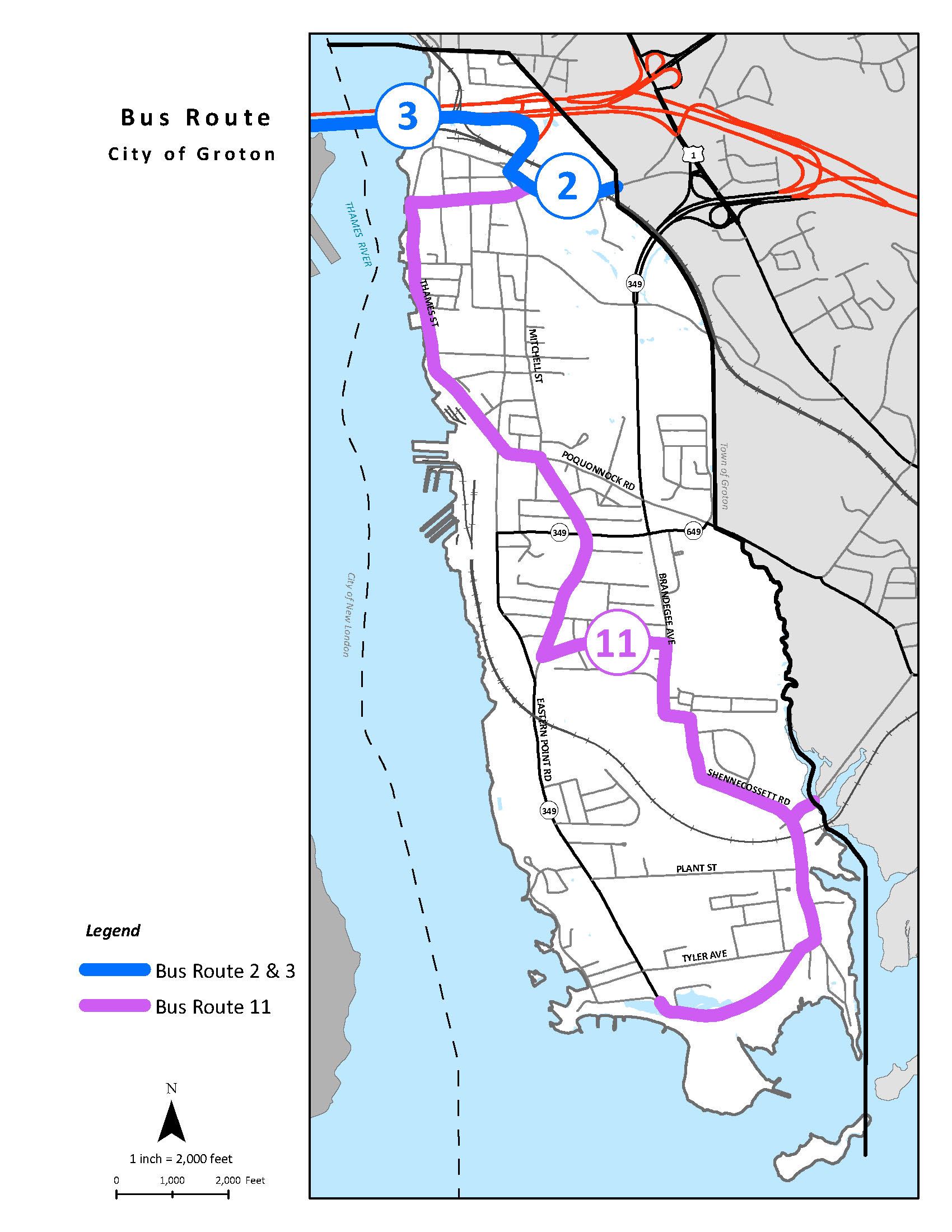
Rail Services / Air Services
The city contains two rail lines but has limited rail service. The main Amtrak northeast rail corridor runs through the city, but the nearest stations are in New London and Stonington. Another line operated by the Providence and Worcester (P&W) provides occasional rail freight to Buckeye Oil and Electric Boat Corporation.
The Groton - New London Airport (located within the Town of Groton) is the fourth largest airport in the state. The 2017 Groton-New London Airport Master Plan anticipates continuing operations as has been recent practice. Due to the regional economic benefits from this facility, airport service improvements should be encouraged provided that negative impacts to local residents and businesses are minimized (since many operations involve flight paths over residential areas).
Water Taxi
During the summer, a water taxi on the Thames River connects:
- Fort Trumbull State Park in New London,
- City Pier in New London, and
- Thames River Landing in the City of Groton.
The city intends to promote this service and seeks to strengthen pedestrian and bicycle linkages to restaurants, shopping and other attractions on Thames Street and other areas.
Strategies To Maintain an Efficient Transportation System
| Priority | Leader | Partners | |
| Roadway System | |||
| 1. Continue to maintain pavement condition as cost effectively as possible (pavement management), | 6.11 | PW | Council DOT |
| 2. Manage activities along existing roadways in order to preserve the roadway capacity (access management). | 2.22 | PZC | Police DOT Staff |
| 3. Implement traffic calming approaches on selected roadways, as necessary, to address traffic issues. | 6.11 | Police | PW DOT |
| Bus Services | |||
| 4. Support the maintenance and expansion of local and regional public transit services (such as SEAT) to help meet the needs of City residents and businesses. | 5.56 | Council | DOT Staff |
| Rail Services / Air Services | |||
| 5. Support rail service improvements provided that negative impacts to local residents and businesses are minimized. | 7.78 | Staff | |
| 6. Support air service improvements provided that negative impacts to local residents and businesses are minimized. | 5.56 | Staff | |
| Water Taxi | |||
| 7. Promote the water taxi service and strengthen pedestrian and bicycle linkages to restaurants, shopping and other attractions on Thames Street and other areas. | 7.78 | TRHP | PZC EDC Staff |
| Click here for the Responsibility Legend | |||